Showing posts with label Architecture. Show all posts

Sunday, August 18, 2019

Shelter- New Haven

This next project was the big one of the semester. I ended up dropping my class because of personal reasons but I did get quite far in this process regardless.

The site is located on the intersection of Orange street and Chapel street in New Haven, CT. 


The project program was to "design a mix-use space which included transitional housing and residential support in a city center" which was in terms a homeless shelter.


So to jump right into it here were the building specs we needed.


So like any project you need a site analysis.

NOISE AND ACOUSTICAL 


WEATHER

MORE WEATHER


And then you gotta have precedents for your site.


My main intention for this building was to emphasize on the connection of the people and the city. I love utilizing green space as a way of connectivity. It not only draws the building into the skyline of whatever is around it, but especially for this project, it draws the people it's being designed for into it as well. Meaning, these people have been living outside homeless, so anything with a small similarity gives them that much more to feel comfortable with in this transition. "Transitional housing"


This brings me to the precedents of how the design was going to be.


Now we get to the fun stuff, where I start putting it all together.


Hey there Sketch Up, nice to see you again.
So here we have some rough rough elevations. As you can see this is where my semester ended for me. I didn't finish adding windows and such.


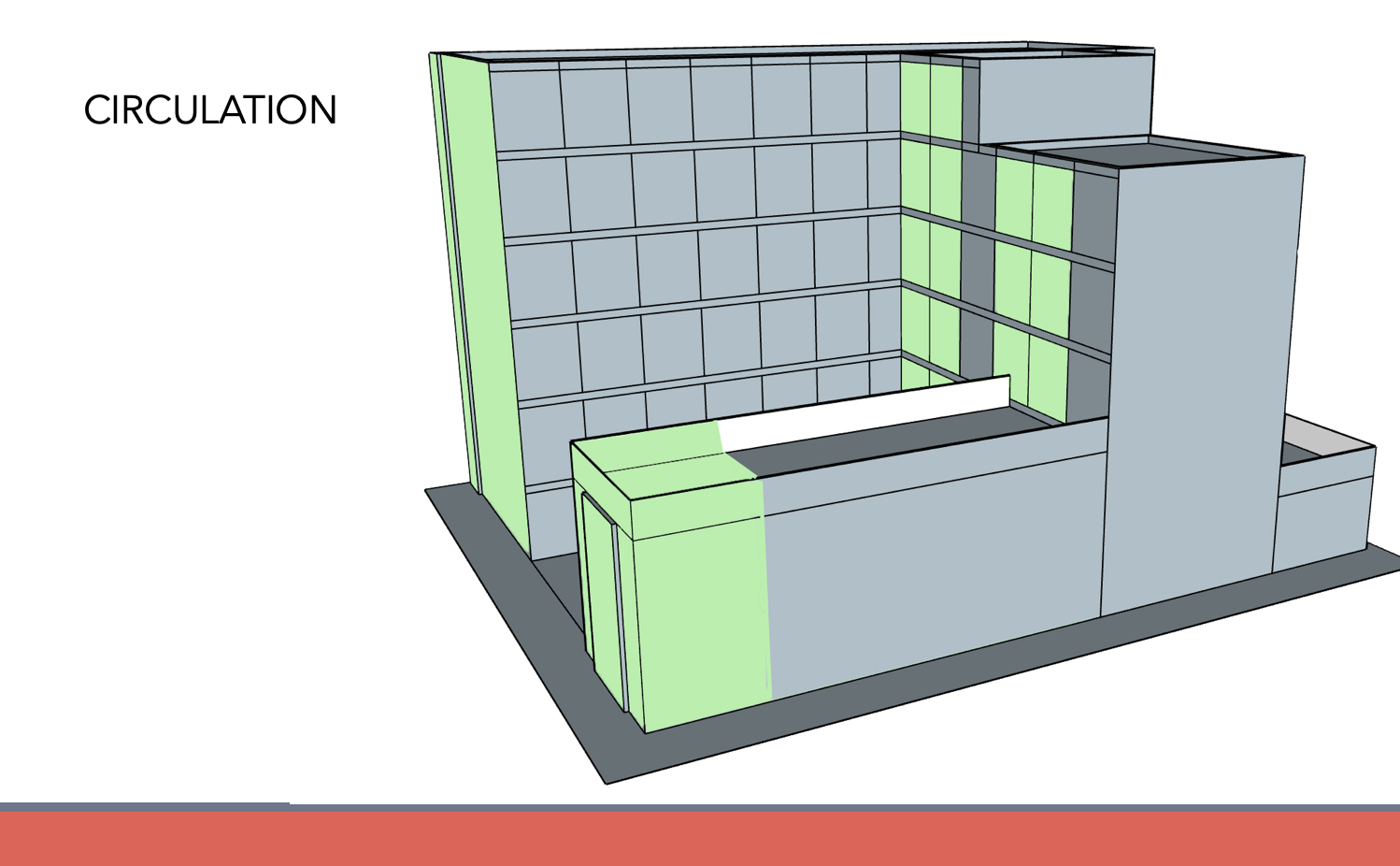
Then I played around with how I would want the circulation to pan out for public vs private spaces of the building.


The bottom two floors consisted of public space where you'd find coffee shops, a little convenient store, mailroom newspaper stand, clinic, etc.


The idea of adding these spaces specifically was one because there was a bus stop right on the corner so a coffee shop, new stand, etc. would be beneficial, and also because adding places where jobs were needed to be filled allowed the homeless people to be able to transition to the work force. 


This last render is the last of what I completed in this project. This angle showcases the ideal of green space and how it connects the whole building and doesn't give a harsh skyline addition. 


Thanks for keeping up with me,

Michelle 


Tuesday, September 19, 2017

Pleasant Pizza Digital Development


Sometime back in March 2016 a friend of mine who owns a pizza shop in Willimantic, CT expressed his interest in expanding his shop. He had goals at the time of opening new spaces for catering, another location in general, and also a patio space. During this time, he was mainly focused on the patio space since Spring was right around the corner. This pizza shop had been around for over 20 years and had created a wonderful base with the community. Their goal was to extend that community to their very own backyard- which is where they wanted the site for their patio to be. The owner had his ideas of what he wanted, how many people he would want to fit, etc. but it was easier said than done. 

I started walking around the space in their backyard, measuring, sampling, and just getting a good idea/site analysis. 


One thing needed to be planned for was the fact that the pizza shop was commercial, but there was residential above. This being said, the surroundings around this patio-to-be space were also all residential. The town's code for building commercial-use into a residential zoned area deemed for a 3' gap between the sidewalk and obstruction (which I learned after my digital work).

Just looking at the backyard space available before actually measuring it, you would assume there was no space at all. But the 70' x ~22' space available said otherwise. 

I started designing a mass model of their property on SketchUp immediately. The accuracy of size, and different tools you can use on this program really help the messy part of the design development stage. 

Thus, the visuals were created. 


Once the owner was able to see just how much space he had to work with, the rest came and went. I was not present for the construction part of this project but they had many people helping from around the town which is exactly what they wanted to do for the community overall- bring people together. This project's construction probably took around 3 months total. Navigating through codes for a residential/commercial-use site was a daily obstacle for them during construction. But, the final product finished outstandingly. 


Construction Phase


End Result


 Thanks for keeping up with me, 


Michelle C Harter


Wednesday, September 13, 2017

Design 4- Uhart Edition Project 1 (Group)

The last post I left you with my reasoning on why I moved to New England, and how my schooling was different than Florida lessons and everything else that comes to moving.
Now the beginning of Design 4 Uhart edition (D4UH) began with picking our brains on what we thought a functional multi-use facade looked like.

Week 2 of D4UH (Recap)

After we did process after process of something that seemed easy as pie, we started thinking completely opposite- not the building or the look, but the people and culture of the community. These facades are famous in New England, but why. That was the the new thought process direction we took. We started researching community demographics, cultures, things that made this area the way it was. 

Before I get ahead of myself, our site was in Sheldon Charter Oak- a neighborhood in Hartford, CT. The whole idea of using this site was to take an average community, on the not so average economic levels and add life to the community without hindering the original culture. 


 Demographics


Site Analysis
 
Once we studied enough of the site, we came to a few conclusions. There were a lot of empty parking lots, and not a lot of people to fill those spots. Adding retail shops and restaurants would bring more people to this part of Hartford, which would accomplish bringing life to this community. But, after studying the communities demographics and basic cultural aspect of this neighborhood, we concluded that adding big name brands and chains to this area would inevitably break the culture and make this yet another 9-5 community. Having chains and big brands come in will add the possibilities of job, which we intended to keep in mind, but the demographics show that these people living here and mainly families, and a lot of which are on lower salaries/fixed incomes. This neighborhood would greatly benefit from the addition of stores and restaurants on the smaller business scale. This would add job opportunities, still bring in the 9-5 Hartford population, but it would also keep the culture of the community intact by creating a bond with the neighborhood. 


Precedent Pictures


Proposed Site Additions Layout


After we gathered all of this information and presented it as a group, we were each broken up for a solo project to execute a multi-use building on our actual neighborhood site. 

Thanks for keeping up with me, 

Michelle C Harter


Saturday, April 23, 2016

Design 4 and THATS a wrap

So it's safe to say that Design 4 took my brain and changed anything I thought was real, and made it the complete opposite.


  • Your work doesn't count if you can't describe the inner emotions of the drawings' soul. 
  • You must use a scale, be unique, but use the scale correctly. Oh wait we never taught you how to scale for more than 3 minutes, good luck!!
  • Why don't you have "landscape"? *Sees everyone turn in models with a base* SO BUILDING WITH A BASE IS ACCEPTABLE NOW.
  • When you draw sections your walls, floors, and ceiling thicknesses must make sense, but remember to be unique and go outside the box with your work. Thats wrong, why did you do that. 
Whoever thought up this curriculum really has an exuberant amount of joy in melting, freezing, and chipping off the pieces of student's brains. 


So we can begin with the Savannah Georgia site trip, being that it took up most of the curriculum for the semester. 

We all drove to Savannah and took a walking tour of Downtown Savannah, starting at  Forsyth park and walking through to Porters Walk. We evaluated the way a city grid evolved and we each tied a personal niche to our experience. We were told to use that personal passion as a mold for how we evolved throughout the two sites. Some included velocity, footsteps, organization, photography, etc.   

My passion was footsteps, having to do with running and how the ground condition highlights the evolution we force off of impact. I decided that since running is a concept that has no plan when you go out to do it, all pieces of the site were fair game to build upon. 


A little while after we went through Downtown Savannah, we ventured to Fort Pulaski. We continued to the far Northern part of the site where the bunker sat below the entrance of the "dock" that went a little over where the water met the marsh land. This water line was a key component to all of our site designs. We were able to dig around the dock and bunker, but couldn't take anything from those two pieces. Everything else was fair game to build elevation upon, or dig away from. 


These two relief models allowed us to start playing with the idea of what and where we really could start to take away and add to the site. The organic pieces of the site played a heavy roll in marking what can change with time vs. by the human imprint. I utilized the idea of the ground condition and how with the human imprint, you can see the evolution's history. Just by the idea that running maps will always have a dictation on where to go, there are always other paths you can venture out to take. and with those other possibilities, the human imprint evolves the space given to them, even if it isn't printed out on a map. 

The site model I came up with took a very layered look to emphasize the ground condition and its importance to the rest of the site. The scale was at 1"=40'.


Once the site model was understood, I could zoom in to one of my spaces in the site. All together we had three spaces- the research, observation, and display space. The site model was at a scale of 1/8"=1'.


The site model took the research space. This was based on the fact how runners do make their own trails. Theres never a set trail you plan to take, of course there is always one there, but the average runner enjoys the discovery within the run. 

Research Space Diagrams (1/16"=1')


Observation Space Diagrams (1/16"=1')

Display Space Diagram (1/16"=1')


From top to bottom: Research, Observation, Display Space


This project began maybe the 1 month of the semester starting off with the Savannah trip itself. The city aspect continued into the midterm, which included the city "map" conveying our passion. We still used the same ideas when moving forward to the final project which focused on Fort Pulaski and the site we were building and taking from. 

Thanks for keeping up with me,

Michelle C. Harter